
Case Study: Creating an innovative wayfinding solution with GuideSIGN
Advertorial
August 2025
Overview
The team at Impact Traffic and Transport Engineering was asked to provide a series of signs for a busy intersection at one of the largest state infrastructure projects in Victoria, Australia. The project involved the rerouting of a major arterial road to a narrower local road, via a complex series of intersections. Ensuring that traffic could be safely directed through the new route for the years’ long construction period, the IMPACT team was tasked to implement a wayfinding solution. To support them in the task, they turned to GuideSIGN, Transoft Solutions’ road sign design software.
Challenge
The new traffic pattern around the construction zone required vehicles to flow from a four-lane road through to a much narrower local road.
The challenge was heightened by the fact that the arterial road also caters for freight vehicles. Massive trucks, such as B-doubles and B-triples, which tow two to three trailers and extend up to 36.5 meters (nearly 120 feet) need to be notified of any route changes well in advance.
The IMPACT team also had to factor in the limited space for signs along the route, as well as time constraints.
All signage had to meet state-approved guidelines, and, most importantly, had to be visible, easy to understand, and facilitate the safe navigation of the new road network by all motorists.
Solution and Results
Deciding on the sign size and mounting system was a first step. Due to the amount of information that had to be conveyed along the route the signs were designed to be large. However, such a solution would also require that the IMPACT team be resourceful in finding appropriate mounting solutions, given the site constraints. By using GuideSIGN, the IMPACT team was able to quickly design different concepts, communicate with gantry and pole manufacturers, and explore the options.
The IMPACT team opted for splitting the signs and mounting them on six-meter poles (nearly 20 feet) each side of the carriageway. By splitting the signs into smaller sizes, they would be installed at the preferred critical locations where conveying information is essential, and with no disruption to underground services. Additionally, this approach helped reduce installation costs, enabling the project team to install additional supplementary signs as needed.

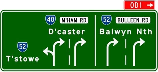
However, that decision required the IMPACT team to take a different approach in the design of the signs. As many of the suburb names to appear on the signs were lengthy, it was necessary to abbreviate them so that they fit on smaller signs. Using state-approved shorthand, they truncated names like Doncaster to D’caster and Heidelberg to H’berg.
While the signs abbreviated the needed information, the IMPACT team was able to use the features of GuideSIGN to demonstrate how the size of the sign text and symbols would meet state standards, and that the signs would be large enough and high enough for all drivers to see. With this, the team was able to secure the state’s approval.
One of the biggest benefits of using GuideSIGN, according to the IMPACT team, was that it enabled them to quickly design and present sign concepts. There were many discussions with key stakeholders during the design process, and for each round of feedback the IMPACT team was able to make revisions or create new mock-ups for presentation by the next day.
Given that GuideSIGN’s templates and libraries automatically ensure all sign aspects, such as text dimensions (height, width, spacing), reflect state-approved standards, the IMPACT team could also trust that any sign they designed met requirements. Furthermore, GuideSIGN’s automated offsets and measurements ensure signs conform with sign manufacturer specifications and that any signs can be easily and reliably produced.
The IMPACT team says GuideSIGN was instrumental in helping them develop the different options that overcame the project’s constraints.
For IMPACT, this project was testament to ways GuideSIGN can be used. It simply helped to come up with custom innovative solutions, whilst overcoming challenges. The IMPACT team says they are always looking for ways to help clients be more flexible in creating and designing roads, and that use of effective directional signage is one way of achieving that.
IMPACT delivers Traffic and Transport Engineering solutions through a unique 'Inspiring Possibilities' approach. IMPACT brings a premium service that is delivered through two specialist offerings: Land Use Planning and Traffic Management. IMPACT's offer is extended to build environment professionals and delivers better outcomes and longer-term partnerships. Click here to learn more about IMPACT
Since 1991, Transoft Solutions has developed advanced and highly specialised software solutions for aviation, civil infrastructure, transportation and operational professionals. Our portfolio of planning, simulation, modeling, design, and road safety analysis solutions is used every day by thousands of organisations in over 150 countries worldwide. Clients include government agencies at the federal, state, county and municipal levels, as well as major international airports and top engineering and architectural design firms. To learn more, visit the Transoft website.